

The map of China from the first English atlas of the world
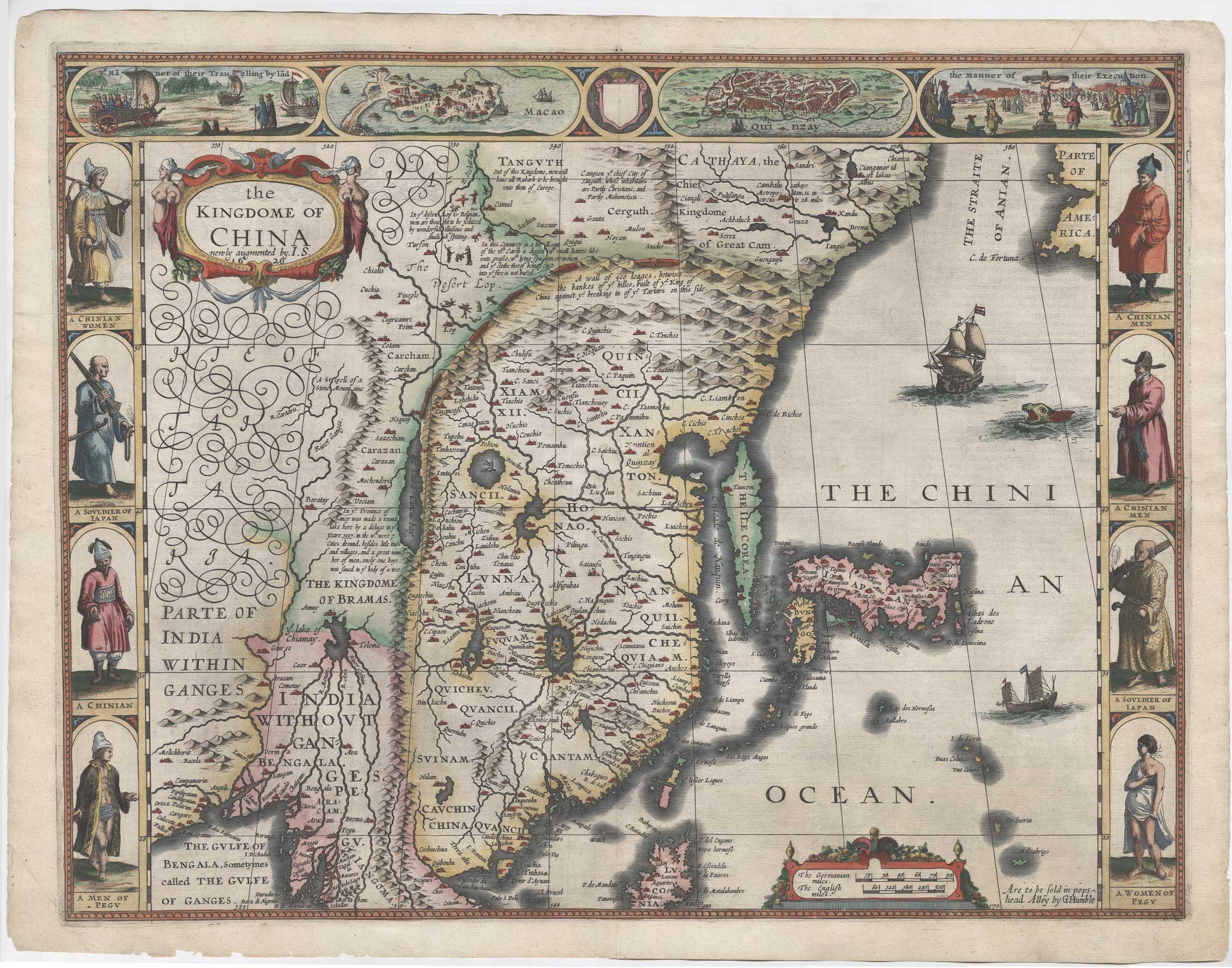
The Kingdome of China newly augmented by J.S. 1626.
London: George Humble, 1627. Coloured. 400 x 520mm.
£3,800.00
1 in stock
x
Question About This Item?
The map of China from the first English atlas of the world & SPEED, John.Stock #: 26497"*" indicates required fields
Similar to Sell?
Add to Wishlist
Add to Wishlist
Description
A very fine example of the 'carte-à-figure' map of China, Korea and Japan, from Speed's 'Prospect of the Most Famous Parts of the World', the first English world atlas.
Most of the information is taken from the Ortelius map of 1584, but it has been redrawn with north at the top and the 'island' of Korea has been added, as well as a recognisable Luzon in the Philippines. Outside the Great Wall of China devils fill the 'Desert Lop' in Mongolia. In Indochina is the mythical 'Lake of Chiamay', source of the major rivers of the region, including the Indus, Ganges & Mekong. Further north the map ends at the 'Straite of Anian', with 'Parte of America' containing one name, 'C. de Fortuna'.
Along the top of the map are four vignettes: plans of Macao and Quinzay (Hangzhou) and illustrations of land yachts and executions. Down the sides are eight costume illustrations.
Condition:
A good example.Related products
-

The first Western atlas of China
BLAEU, Johannes. Date: 1655Stock #: 20044 £29,000.00 -

Victorian blue-back chart of China and Vietnam
IMRAY, James. Date: 1872Stock #: 22589 £1,100.00 -

An Italian edition of an account of the Amherst Embassy to China
ELLIS, Henry. Date: 1819Stock #: 23936 £400.00 -

A scarce map of China
CASSINI, Giovanni Maria. Date: 1798Stock #: 20552 £650.00 -

18th century map of China
KITCHIN, Thomas. Date: 1747Stock #: 19967 £280.00 -

De Jode’s scarce map of China
DE JODE, Cornelis. Date: 1593Stock #: 26608 £27,000.00 -

An 18th century playing-card map of China
RABATTA, Augusto & BAILOU, Jean Baptist de. Date: 1779Stock #: 12974 £450.00 -
A scarce 17th century map of China by a French Jesuit
LE COMPTE, Louis. Date: 1698Stock #: 23440 £1,600.00 -

19th century China and Burma
Society for the Diffusion of Useful Knowledge. Date: 1834Stock #: 21976 £180.00
Items by the same author
Add to Wishlist
Add to Wishlist
Add to Wishlist
Add to Wishlist
Add to Wishlist
Add to Wishlist

Add to Wishlist
Add to Wishlist
Add to Wishlist
Add to Wishlist

The first atlas map of the world to show California as an island
SPEED, John. Date: 1655 Stock #: 26500 £13,000.00
Add to Wishlist
Add to Wishlist